This is an interactive map! Use controls to pan and zoom this map.
Access
|
English (Translate this text in English): From Cavalaire, or Saint-Topez Harbour.
The submarine is located near the famous beach of Pampelone.
English (Translate this text in English): From Cavalaire, or Saint-Topez Harbour.
The submarine is located near the famous beach of Pampelone.
From Cavalaire, or Saint-Topez Harbour.
The submarine is located near the famous beach of Pampelone.
English (Translate this text in English): From Cavalaire, or Saint-Topez Harbour.
The submarine is located near the famous beach of Pampelone.
English (Translate this text in English): From Cavalaire, or Saint-Topez Harbour.
The submarine is located near the famous beach of Pampelone.
English (Translate this text in English): From Cavalaire, or Saint-Topez Harbour.
The submarine is located near the famous beach of Pampelone.
English (Translate this text in English): From Cavalaire, or Saint-Topez Harbour.
The submarine is located near the famous beach of Pampelone.
English (Translate this text in English): From Cavalaire, or Saint-Topez Harbour.
The submarine is located near the famous beach of Pampelone.
English (Translate this text in English): From Cavalaire, or Saint-Topez Harbour.
The submarine is located near the famous beach of Pampelone.
How? By boat
Distance Good boat time (< 30min)
Easy to find? Hard to find
|
|
Dive site Characteristics
Average depth 34.0 m / 111.5 ft
Max depth 38.0 m / 124.7 ft
Current Medium ( 1-2 knots)
Visibility Excellent ( > 30 m)
Quality
Dive site quality Great
Experience CMAS *** / Rescue
Bio interest Outstanding
More details
Week crowd
Week-end crowd
Dive type
- Wreck
Dive site activities
- Photography
Dangers
- Depth
- Current
- Boat trafic
Additional Information
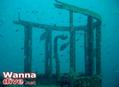
English (Translate this text in English): This submarine was a mine-layer, launched in 1931 for the Franch Navy. Length: 66m.
After the war, it was sunk on purpose by the Navy in 1958, to serve as a sonar target.
This is one of the most beautiful dives from the French Riviera. Ideal for a Nitrox 30 mix. When diving with air, do not stay more than 15 minutes at the bottom to avoid long decompression stops. Beware of currents both on the surface and on the wreck. The sealife in the wreck is magnificent: groupers, lobsters, moray eels, conger eels, etc. It is not recommended to penetrate inside the wreck (risk of entanglement, low visibility due to sediments). There exist only 2 other submarines on the french riviera: one at an extreme depth (127m) called "Le Protee" near Cassis, which is a designated war grave, and another "L'Ariane" which lies at 30m in a military area and thus requires a special permission (near Cap Cepet, Toulon).
Exact GPS coordinates
SHOM#18036007
Lon: 06° 42,0451' E
Lat: 43° 11,2567' N
WGS84
This submarine was a mine-layer, launched in 1931 for the Franch Navy. Length: 66m.
After the war, it was sunk on purpose by the Navy in 1958, to serve as a sonar target.
This is one of the most beautiful dives from the French Riviera. Ideal for a Nitrox 30 mix. When diving with air, do not stay more than 15 minutes at the bottom to avoid long decompression stops. Beware of currents both on the surface and on the wreck. The sealife in the wreck is magnificent: groupers, lobsters, moray eels, conger eels, etc. It is not recommended to penetrate inside the wreck (risk of entanglement, low visibility due to sediments). There exist only 2 other submarines on the french riviera: one at an extreme depth (127m) called "Le Protee" near Cassis, which is a designated war grave, and another "L'Ariane" which lies at 30m in a military area and thus requires a special permission (near Cap Cepet, Toulon).
Exact GPS coordinates
SHOM#18036007
Lon: 06° 42,0451' E
Lat: 43° 11,2567' N
WGS84
English (Translate this text in English): This submarine was a mine-layer, launched in 1931 for the Franch Navy. Length: 66m.
After the war, it was sunk on purpose by the Navy in 1958, to serve as a sonar target.
This is one of the most beautiful dives from the French Riviera. Ideal for a Nitrox 30 mix. When diving with air, do not stay more than 15 minutes at the bottom to avoid long decompression stops. Beware of currents both on the surface and on the wreck. The sealife in the wreck is magnificent: groupers, lobsters, moray eels, conger eels, etc. It is not recommended to penetrate inside the wreck (risk of entanglement, low visibility due to sediments). There exist only 2 other submarines on the french riviera: one at an extreme depth (127m) called &quot;Le Protee&quot; near Cassis, which is a designated war grave, and another &quot;L'Ariane&quot; which lies at 30m in a military area and thus requires a special permission (near Cap Cepet, Toulon).
Exact GPS coordinates
SHOM#18036007
Lon: 06° 42,0451' E
Lat: 43° 11,2567' N
WGS84
English (Translate this text in English): This submarine was a mine-layer, launched in 1931 for the Franch Navy. Length: 66m.
After the war, it was sunk on purpose by the Navy in 1958, to serve as a sonar target.
This is one of the most beautiful dives from the French Riviera. Ideal for a Nitrox 30 mix. When diving with air, do not stay more than 15 minutes at the bottom to avoid long decompression stops. Beware of currents both on the surface and on the wreck. The sealife in the wreck is magnificent: groupers, lobsters, moray eels, conger eels, etc. It is not recommended to penetrate inside the wreck (risk of entanglement, low visibility due to sediments). There exist only 2 other submarines on the french riviera: one at an extreme depth (127m) called &amp;quot;Le Protee&amp;quot; near Cassis, which is a designated war grave, and another &amp;quot;L'Ariane&amp;quot; which lies at 30m in a military area and thus requires a special permission (near Cap Cepet, Toulon).
Exact GPS coordinates
SHOM#18036007
Lon: 06° 42,0451' E
Lat: 43° 11,2567' N
WGS84
English (Translate this text in English): This submarine was a mine-layer, launched in 1931 for the Franch Navy. Length: 66m.
After the war, it was sunk on purpose by the Navy in 1958, to serve as a sonar target.
This is one of the most beautiful dives from the French Riviera. Ideal for a Nitrox 30 mix. When diving with air, do not stay more than 15 minutes at the bottom to avoid long decompression stops. Beware of currents both on the surface and on the wreck. The sealife in the wreck is magnificent: groupers, lobsters, moray eels, conger eels, etc. It is not recommended to penetrate inside the wreck (risk of entanglement, low visibility due to sediments). There exist only 2 other submarines on the french riviera: one at an extreme depth (127m) called &amp;amp;quot;Le Protee&amp;amp;quot; near Cassis, which is a designated war grave, and another &amp;amp;quot;L'Ariane&amp;amp;quot; which lies at 30m in a military area and thus requires a special permission (near Cap Cepet, Toulon).
Exact GPS coordinates
SHOM#18036007
Lon: 06° 42,0451' E
Lat: 43° 11,2567' N
WGS84
English (Translate this text in English): This submarine was a mine-layer, launched in 1931 for the Franch Navy. Length: 66m.
After the war, it was sunk on purpose by the Navy in 1958, to serve as a sonar target.
This is one of the most beautiful dives from the French Riviera. Ideal for a Nitrox 30 mix. When diving with air, do not stay more than 15 minutes at the bottom to avoid long decompression stops. Beware of currents both on the surface and on the wreck. The sealife in the wreck is magnificent: groupers, lobsters, moray eels, conger eels, etc. It is not recommended to penetrate inside the wreck (risk of entanglement, low visibility due to sediments). There exist only 2 other submarines on the french riviera: one at an extreme depth (127m) called &amp;amp;amp;quot;Le Protee&amp;amp;amp;quot; near Cassis, which is a designated war grave, and another &amp;amp;amp;quot;L'Ariane&amp;amp;amp;quot; which lies at 30m in a military area and thus requires a special permission (near Cap Cepet, Toulon).
Exact GPS coordinates
SHOM#18036007
Lon: 06° 42,0451' E
Lat: 43° 11,2567' N
WGS84
English (Translate this text in English): This submarine was a mine-layer, launched in 1931 for the Franch Navy. Length: 66m.
After the war, it was sunk on purpose by the Navy in 1958, to serve as a sonar target.
This is one of the most beautiful dives from the French Riviera. Ideal for a Nitrox 30 mix. When diving with air, do not stay more than 15 minutes at the bottom to avoid long decompression stops. Beware of currents both on the surface and on the wreck. The sealife in the wreck is magnificent: groupers, lobsters, moray eels, conger eels, etc. It is not recommended to penetrate inside the wreck (risk of entanglement, low visibility due to sediments). There exist only 2 other submarines on the french riviera: one at an extreme depth (127m) called &amp;amp;amp;amp;quot;Le Protee&amp;amp;amp;amp;quot; near Cassis, which is a designated war grave, and another &amp;amp;amp;amp;quot;L'Ariane&amp;amp;amp;amp;quot; which lies at 30m in a military area and thus requires a special permission (near Cap Cepet, Toulon).
Exact GPS coordinates
SHOM#18036007
Lon: 06° 42,0451' E
Lat: 43° 11,2567' N
WGS84
English (Translate this text in English): This submarine was a mine-layer, launched in 1931 for the Franch Navy. Length: 66m.
After the war, it was sunk on purpose by the Navy in 1958, to serve as a sonar target.
This is one of the most beautiful dives from the French Riviera. Ideal for a Nitrox 30 mix. When diving with air, do not stay more than 15 minutes at the bottom to avoid long decompression stops. Beware of currents both on the surface and on the wreck. The sealife in the wreck is magnificent: groupers, lobsters, moray eels, conger eels, etc. It is not recommended to penetrate inside the wreck (risk of entanglement, low visibility due to sediments). There exist only 2 other submarines on the french riviera: one at an extreme depth (127m) called &amp;amp;amp;amp;amp;quot;Le Protee&amp;amp;amp;amp;amp;quot; near Cassis, which is a designated war grave, and another &amp;amp;amp;amp;amp;quot;L'Ariane&amp;amp;amp;amp;amp;quot; which lies at 30m in a military area and thus requires a special permission (near Cap Cepet, Toulon).
Exact GPS coordinates
SHOM#18036007
Lon: 06° 42,0451' E
Lat: 43° 11,2567' N
WGS84
 Comments
Please login to use this tool.
No account yet? Register first; it's free!
Show all (0)...
Be the first to comment this country
Errors, Feedback
You can edit this page to correct errors or add new information. If you have any problems regarding this page, Send us feedback.
 Le Rubis