Lost password? New user? Register
Lizard fish, Philippines. Photo by Stephane Rochon.
Enjoy and contribute!
| Find the best dive sites |
|
|
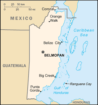
 Belize
Central America
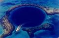
There are great opportunities for scuba diving off of Belize atolls. Don't miss the world class dive site named Blue Hole!
Location: Central America, bordering the Caribbean Sea, between Guatemala and Mexico
Geographic coordinates: 17° 15' N, 88° 45' W
Coastline km: 386 km km
Climate: tropical; very hot and humid; rainy season (May to November); dry season (February to May)
Terrain: flat, swampy coastal plain; low mountains in south
Elevation: lowest point: Caribbean Sea 0 m
highest point: Victoria Peak 1,160 m
Natural hazards: frequent, devastating hurricanes (June to November) and coastal flooding (especially in south)
Currency: Belizean dollar (BZD)
Population: 294,385 (July 2007 est.)
Languages: Spanish 46%, Creole 32.9%, Mayan dialects 8.9%, English 3.9% (official), Garifuna 3.4% (Carib), German 3.3%, other 1.4%, unknown 0.2% (2000 census)
Capital: Belmopan
Divisions: 6 districts; Belize, Cayo, Corozal, Orange Walk, Stann Creek, Toledo
More details
| Jan | Feb | Mar | Apr | May | Jun | Jul | Aug | Sep | Oct | Nov | Dec | |
|---|---|---|---|---|---|---|---|---|---|---|---|---|
| Climate | ||||||||||||
| Air temp. | ||||||||||||
| Water temp. | 27°C | 26°C | 27°C | 28°C | 28°C | 28°C | 28°C | 29°C | 29°C | 29°C | 27°C | 27°C |
| Equipment | ||||||||||||
| Best season | ||||||||||||
Additional map
Wanna add some info about Belize? Let us know...
This is an interactive map! Use controls to pan and zoom this map.
- Favourite
-
Your favourites and future dive site lists
Your favorite zone isn't listed ? Add a zone
Zones
| Zones (3) | Dive sites | Sub zones |
|---|---|---|
| Ambergris Caye | 3 | 0 |
| Lighthouse Reef | 5 | 0 |
| Turneffe Islands | 2 | 0 |
 Dive logs
|
Comments
Be the first to comment this country
Errors, Feedback
If you want to add new information or you have found errors on this country, Send us feedback.
Advertise
Wannadive.net 24/24
Wannadive.net on your mobile
![]()
RSS All the RSS feeds of Wannadive.net
Newsletter All news by email
|
|
|