Lost password? New user? Register
Lizard fish, Philippines. Photo by Stephane Rochon.
Enjoy and contribute!
| Find the best dive sites |
|
|
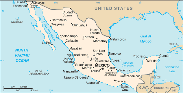
 Mexico
Central America
Location: Middle America, bordering the Caribbean Sea and the Gulf of Mexico, between Belize and the US and bordering the North Pacific Ocean, between Guatemala and the US
Geographic coordinates: 23° 0' N, 102° 0' W
Coastline km: 9,330 km km
Climate: varies from tropical to desert
Terrain: high, rugged mountains; low coastal plains; high plateaus; desert
Elevation: lowest point: Laguna Salada -10 m
highest point: Volcan Pico de Orizaba 5,700 m
Natural hazards: tsunamis along the Pacific coast, volcanoes and destructive earthquakes in the center and south, and hurricanes on the Pacific, Gulf of Mexico, and Caribbean coasts
Currency: Mexican peso (MXN)
Population: 106,202,903 (July 2005 est.)
Languages: Spanish, various Mayan, Nahuatl, and other regional indigenous languages
Capital: Mexico
Divisions: 31 states and 1 federal district* ; Aguascalientes, Baja California, Baja California Sur, Campeche, Chiapas, Chihuahua, Coahuila de Zaragoza, Colima, Distrito Federal*, Durango, Guanajuato, Guerrero, Hidalgo, Jalisco, Mexico, Michoacan de Ocampo, Morelos, Nayarit, Nuevo Leon, Oaxaca, Puebla, Queretaro de Arteaga, Quintana Roo, San Luis Potosi, Sinaloa, Sonora, Tabasco, Tamaulipas, Tlaxcala, Veracruz-Llave, Yucatan, Zacatecas
More details
| Jan | Feb | Mar | Apr | May | Jun | Jul | Aug | Sep | Oct | Nov | Dec | |
|---|---|---|---|---|---|---|---|---|---|---|---|---|
| Climate | ||||||||||||
| Air temp. | ||||||||||||
| Water temp. | ||||||||||||
| Equipment | ||||||||||||
| Best season | ||||||||||||
Additional map
Wanna add some info about Mexico? Let us know...
This is an interactive map! Use controls to pan and zoom this map.
- Favourite
-
Your favourites and future dive site lists
Your favorite zone isn't listed ? Add a zone
Zones
| Zones (5) | Dive sites | Sub zones |
|---|---|---|
| Baja California | 11 | 2 |
| Capital Region | 2 | 1 |
| Central Pacific | 10 | 2 |
| Northwest - Sonora | 6 | 2 |
| Yucatan peninsula | 42 | 3 |


 Dive logs
|
Comments
Be the first to comment this country
Errors, Feedback
If you want to add new information or you have found errors on this country, Send us feedback.
Advertise
Wannadive.net 24/24
Wannadive.net on your mobile
![]()
RSS All the RSS feeds of Wannadive.net
Newsletter All news by email
|
|
|