Lost password? New user? Register
Whale Shark, Philippines. Photo by Stephane Rochon.
Enjoy and contribute!
| Find the best dive sites |
|
|
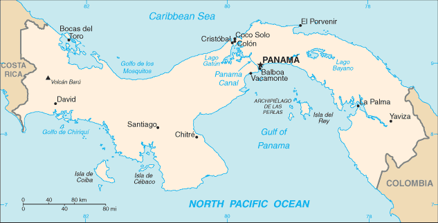
 Panama
Central America
Location: Central America, bordering both the Caribbean Sea and the North Pacific Ocean, between Colombia and Costa Rica
Geographic coordinates: 9° 0' N, 80° 0' W
Coastline km: 2,490 km km
Climate: tropical maritime; hot, humid, cloudy; prolonged rainy season (May to January), short dry season (January to May)
Terrain: interior mostly steep, rugged mountains and dissected, upland plains; coastal areas largely plains and rolling hills
Elevation: lowest point: Pacific Ocean 0 m
highest point: Volcan de Chiriqui 3,475 m
Natural hazards: occasional severe storms and forest fires in the Darien area
Currency: balboa (PAB); US dollar (USD)
Population: 3,191,319 (July 2006 est.)
Languages: Spanish (official), English 14%; note - many Panamanians bilingual
Capital: Panama
Divisions: 9 provinces and 1 territory*: Bocas del Toro, Chiriqui, Cocle, Colon, Darien, Herrera, Los Santos, Panama, San Blas*(Kuna Yala), and Veraguas
More details
| Jan | Feb | Mar | Apr | May | Jun | Jul | Aug | Sep | Oct | Nov | Dec | |
|---|---|---|---|---|---|---|---|---|---|---|---|---|
| Climate | ||||||||||||
| Air temp. | ||||||||||||
| Water temp. | ||||||||||||
| Equipment | ||||||||||||
| Best season | ||||||||||||
Additional map
Wanna add some info about Panama? Let us know...
This is an interactive map! Use controls to pan and zoom this map.
- Favourite
-
Your favourites and future dive site lists
Your favorite zone isn't listed ? Add a zone
Zones
| Zones (2) | Dive sites | Sub zones |
|---|---|---|
| Colon | 0 | 1 |
| Veraguas & Isla Coiba | 2 | 1 |
 Comments
Be the first to comment this country
Errors, Feedback
If you want to add new information or you have found errors on this country, Send us feedback.
Advertise
Wannadive.net 24/24
Wannadive.net on your mobile
![]()
RSS All the RSS feeds of Wannadive.net
Newsletter All news by email
|
|
|