Lost password? New user? Register
Big eye, Philippines. Photo by Stephane Rochon.
Enjoy and contribute!
| Find the best dive sites |
|
|
 Vanuatu
Australia & Pacific
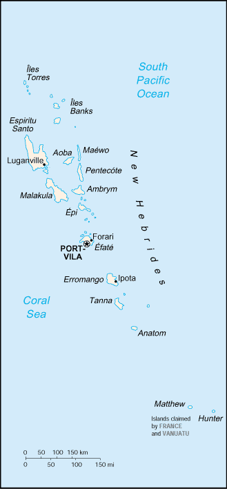
Location: Oceania, group of islands in the South Pacific Ocean, about three-quarters of the way from Hawaii to Australia. Vanuatu, formerly called New Hebrides, is more than 80 islands, about 65 of which are inhabited.
Geographic coordinates: 16° 0' S, 167° 0' E
Coastline km: 2,528 km km
Climate: tropical; moderated by southeast trade winds from May to October; moderate rainfall from November to April; may be affected by cyclones from December to April
Terrain: mostly mountainous islands of volcanic origin; narrow coastal plains
Elevation: lowest point: Pacific Ocean 0 m
highest point: Tabwemasana 1,877 m
Natural hazards: tropical cyclones or typhoons (January to April); volcanic eruption on Aoba (Ambae) island began 27 November 2005, volcanism also causes minor earthquakes; tsunamis
Currency: vatu (VUV)
Population: 208,869 (July 2006 est.)
Languages: local languages (more than 100) 72.6%, pidgin (known as Bislama or Bichelama) 23.1%, English 1.9%, French 1.4%, other 0.3%, unspecified 0.7%
Capital: Port-Vila (on Efate)
Divisions: 6 provinces; Malampa, Penama, Sanma, Shefa, Tafea, Torba
More details
| Jan | Feb | Mar | Apr | May | Jun | Jul | Aug | Sep | Oct | Nov | Dec | |
|---|---|---|---|---|---|---|---|---|---|---|---|---|
| Climate | ||||||||||||
| Air temp. | ||||||||||||
| Water temp. | ||||||||||||
| Equipment | ||||||||||||
| Best season | ||||||||||||
Additional map
Wanna add some info about Vanuatu? Let us know...
This is an interactive map! Use controls to pan and zoom this map.
- Favourite
-
Your favourites and future dive site lists
Your favorite zone isn't listed ? Add a zone
Zones
| Zones (2) | Dive sites | Sub zones |
|---|---|---|
| Efaté Island (Port-Vila) | 16 | 1 |
| Espiritu Santo Island | 5 | 0 |


 Dive trips
|
Comments
Be the first to comment this country
Errors, Feedback
If you want to add new information or you have found errors on this country, Send us feedback.
Advertise
Wannadive.net 24/24
Wannadive.net on your mobile
![]()
RSS All the RSS feeds of Wannadive.net
Newsletter All news by email
|
|
|